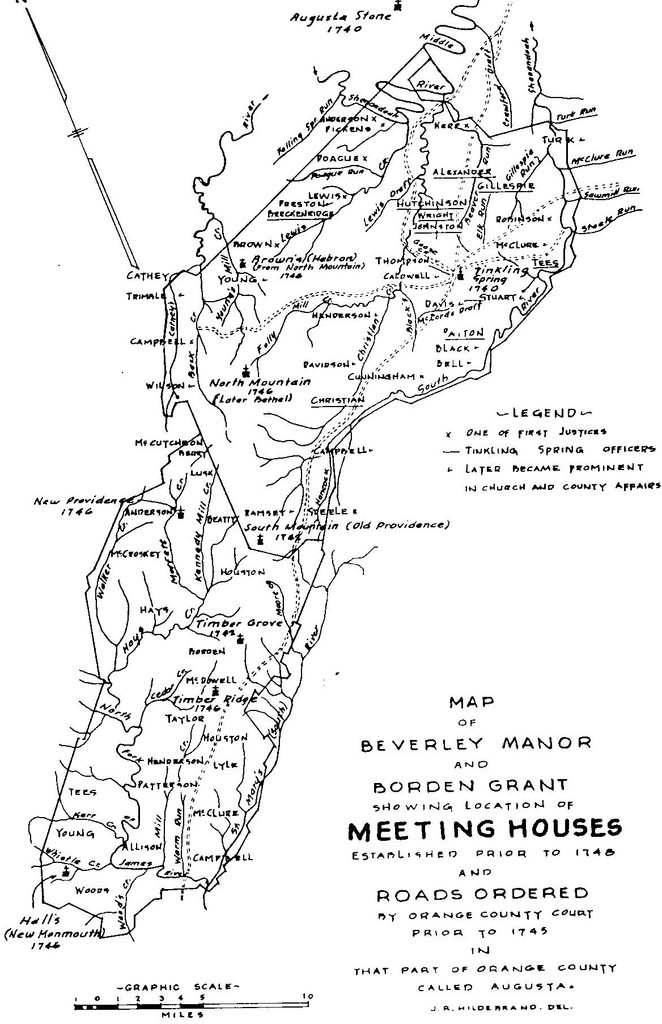
In the above picture you can see where “Wood’s Creek” is at the bottom of the map, on the right side. Abraham had 435 acres in that area. Abraham Brown’s farm was in the triangle of Wood’s Creek and the James River. Abraham was appointed Constable of that area called the Brushy Hills. This is the first Brown Family settlement in the Colonies after Abraham and his wife and son’s immigration in 1729.
I asked Chatgpt to give me an overview of what Borden’s Grant was and how Benjamin Borden came to possess it. Here is the answer:
Borden’s Grant was a massive 92,100-acre land tract in the Shenandoah Valley of colonial Virginia, located primarily in what is now Rockbridge County and parts of Augusta County. It was issued in the early 18th century as part of Virginia’s strategy to settle and defend the western frontier.
This grant became one of the most important early land settlements west of the Blue Ridge Mountains and played a central role in the development of the Shenandoah Valley.
Benjamin Borden Sr. (1675–1743) was a Quaker land speculator from New Jersey. He became a prominent figure in Virginia through his connections and land dealings during the 1730s. His efforts helped open up the Shenandoah Valley to large-scale settlement by European immigrants—particularly Scots-Irish and Germans.
In 1739, Borden received a patent (land grant) from the Governor and Council of Colonial Virginia, promising him a large tract of land if he could bring in 100 settlers (families). This was a common method the colonial government used to encourage organized migration and frontier expansion.
Here’s how it unfolded:
- Borden petitioned for land in the Valley, citing his ability to recruit settlers.
- He was granted 92,100 acres, with the stipulation that he recruit and settle 100 families to occupy and cultivate it.
- Borden succeeded in attracting settlers—many of whom were Scots-Irish Presbyterians and German Lutherans fleeing religious and economic hardship in Europe and Pennsylvania.
- After fulfilling the settlement condition, he received full legal title to the entire grant in 1741.
Legacy and Importance of Borden’s Grant
- The grant area includes modern towns like Lexington, Virginia, and much of Rockbridge County.
- Borden and his descendants sold parcels to settlers, and these transactions laid the foundation for communities, churches, and farms that remain today.
- Borden himself is buried in what became known as the Timber Ridge Presbyterian Church Cemetery—one of the earliest in the area.
Borden’s Grant was a 92,100-acre land tract in colonial Virginia, granted to Benjamin Borden Sr. in 1739 on the condition that he recruit 100 families to settle there. Located in today’s Rockbridge County, the grant helped open the Shenandoah Valley to waves of Scots-Irish and German settlers. Borden fulfilled the settlement requirement and was awarded full title in 1741, shaping the future of the region as a center of agriculture, culture, and frontier life.
Information provided by AI, Chatgpt
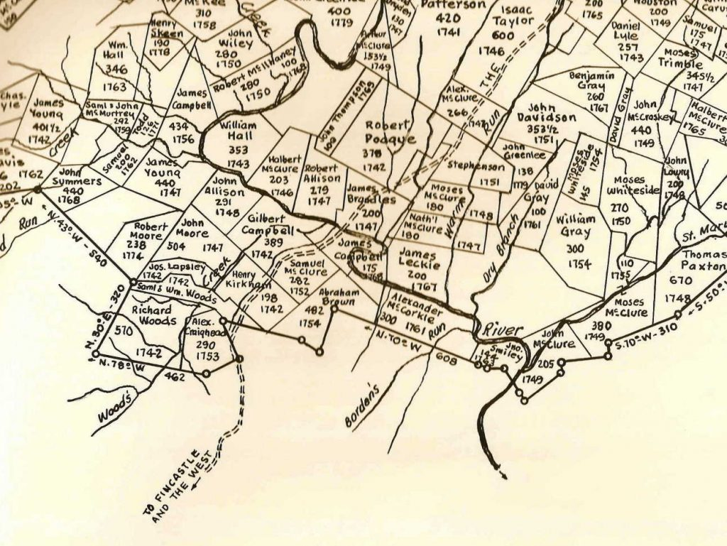
In the cross-section map below, you can see the name Abraham Brown. He owned 482 acres and was deeded title to the land in 1754. Abraham’s son, Abraham Jr, married the daughter of Henry Kirkham whose property is to the right of Abraham’s land. Henry Kirkham owned 198 acres and received the deed in 1742. Abraham Brown (born 1700) who is the subject of this page, had the deed placed in the name of his son, Abraham Brown, Jr. born 1730.
Before arriving at Borden’s Grant our direct ancestor took the “Great Wagon Road” south to Virginia.
Here are some articles and links about the Great Wagon Road as provided by research on Chatgpt:
🛣️ What Was the Great Wagon Road?
The Great Wagon Road stretched from Philadelphia, Pennsylvania, down through the Shenandoah Valley of Virginia, and continued into North Carolina, South Carolina, and Georgia. It followed earlier Native American trails—primarily the Great Indian Warpath—and became a vital artery for migration, commerce, and cultural exchange during the 18th century.
- Length: Over 800 miles
- Time Period: Most heavily used between 1730s–1800
- Purpose: Migration, trade, and settlement
- Users: Primarily Scots-Irish, German (Palatine), and English settlers
- Route Highlights:
- Philadelphia
- Lancaster
- York
- Gettysburg
- Hagerstown
- Winchester
- Staunton and Lexington (Virginia)
- Salem and Salisbury (North Carolina)
- Ends in Augusta, Georgia
🌐 Recommended Websites to Link
1. Great Wagon Road – Wikipedia
A detailed article covering the road’s route, history, and evolution from Indian trails to colonial roadways.
👉 https://en.wikipedia.org/wiki/Great_Wagon_Road
2. Piedmont Trails – The Great Wagon Road Project
A passionate and well-documented site focused on the road’s legacy, individual stories, and how modern roads trace the original route.
👉 https://piedmonttrails.com/the-great-wagon-road-project/
3. Explore the Great Wagon Road – Journal of the American Revolution
Offers historical analysis and geographic context for researchers and history buffs.
👉 https://allthingsliberty.com/2018/05/explore-the-great-wagon-road/
4. Library of Congress – Early Maps of Colonial Roads
Includes maps and primary sources documenting early American roads, including the Great Wagon Road.
👉 https://www.loc.gov
5. Our State Magazine – Following the Great Wagon Road
A modern-day reflection on traveling the road’s path through North Carolina, rich with local history.
👉 https://www.ourstate.com/following-the-great-wagon-road/